Ocean
Science Studies
Coastal ocean ecosystems are under enormous pressure from human activities, both from harvesting and from materials entering the coastal ocean from the land and the atmosphere. Compared with the open ocean, these regions contain greatly enhanced amounts of phytoplankton, sediments and dissolved organic matter. The high productivity of the coastal ocean supports a complex food web and leads to a disproportionate harvesting of the world’s seafood from the coastal ocean regions. Persistent hypoxic events or regions associated with riverine discharge of nutrients (such as in the Gulf of Mexico), the increasing frequency of harmful algal blooms in the coastal waters of the United States, and extensive closures of coastal fisheries are just a few of the issues confronting the coastal areas.
Both short-term and long-term forecasts of the coastal ocean require better understanding of critical processes and sustained observing systems. Characterizing and understanding the short-term dynamics of coastal ecosystems are essential for the development of robust, predictive models of the effects of climate change and human activity on coastal ocean ecosystem structure and function. The scales of variability in the coastal region require measurements at high temporal and spatial resolution that can be obtained only from continuous observation, such as is possible from geosynchronous Earth orbit.
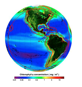 Geostationary view from 95° W for the GEO-CAPE coastal ecosystem sensor overlain on the SeaWiFS chlorophyll-a mission composite. The red outer circle encompassing much of North and South America represents the region within the 67° sensor view angle, which is the approximate limit to ocean color retrievals from 95° W. The two red lines extending beyond the continental land masses represent 375 km and 500 km distances from the inland boundary to the oceans. Both lines generally extend beyond the 2500 m bathymetry of the continental margin (demarcated by the black line). Image courtesy of Dirk Aurin. SeaWiFS chlorophyll-a data courtesy of the NASA GSFC Ocean Biology Processing Group.
The Ocean Science Questions address short-term processes, land-ocean exchange, the impacts of climate change & human activity on productivity and biodiversity, the impacts of airborne-derived fluxes, and episodic events & hazards. They are traceable to NASA’s Ocean Biology and Biochemistry (OBB) Advanced Planning Document, as indicated by the numbers in parentheses following each question. Access the Earth’s Living Ocean: ‘The Unseen World’ OBB Report [PDF]
- How do short-term coastal and open ocean processes interact with and influence larger scale physical, biogeochemical and ecosystem dynamics? (OBB1)
- How are variations in exchanges across the land-ocean interface related to changes within the watershed, and how do such exchanges influence coastal and open ocean biogeochemistry and ecosystem dynamics? (OBB1 & 2)
- How are the productivity and biodiversity of coastal ecosystems changing, and how do these changes relate to natural and anthropogenic forcing, including local to regional impacts of climate variability? (OBB1, 2 & 3)
- How do airborne derived fluxes from precipitation, fog and episodic events such as fires, dust storms & volcanoes significantly affect the ecology and biogeochemistry of coastal and open ocean ecosystems? (OBB1 & 2)
- How do episodic hazards, contaminant loadings, and alterations of habitats impact the biology and ecology of the coastal zone? (OBB4)
These Science Questions guided the development of the Oceans Science Traceability Matrix [PDF] and Planning Studies have guided the evolution of the measurement requirements.
Addressing these Science Questions requires a sensor that is capable of providing improved spectral resolution and temporal coverage relative to what is presently available from OC sensors. The higher frequency observations from GEO-CAPE will help mitigate the effects of cloud cover, as well as better resolve the dynamic, episodic, and/or ephemeral processes, phenomena and conditions commonly observed in coastal regions. A geostationary coastal sensor located near 95°W on the equator would image coastal waters between areas off eastern South America and the northwestern U.S..
GEO-CAPE will observe coastal regions at sufficient temporal and spatial scales to resolve near-shore processes, tides, coastal fronts, and eddies, and track carbon pools and pollutants. Two complementary operational modes will be employed: (1) survey mode for evaluation of diurnal to inter-annual variability of constituents, rate measurements and hazards for estuarine and continental shelf and slope regions with linkages to open-ocean processes at appropriate spatial scales, and (2) targeted, high-frequency sampling for observing episodic events including evaluating the effects of diurnal variability on upper ocean constituents and assessing the rates of biological processes and coastal hazards.
The spectral range of the GEO-CAPE coastal sensor must span from the ultraviolet to near-infrared plus short-wave infrared (SWIR) bands with high temporal and spatial resolution. A denser and more comprehensive ocean color data set will result, allowing for further development, use and operational implementation of more timely and accurate products, e.g., harmful algal bloom forecasts. This, in turn, will provide better information to users in support of management and decision/policy making needs.
Field campaigns have been conducted and planned to obtain detailed oceanographic and atmospheric observations for characterizing short-term dynamics and spatio-temporal variability in atmospheric and coastal ecosystem processes.
Instrument Design
Ongoing studies continue to refine GEO-CAPE measurement and instrument requirements. Specific instruments for GEO-CAPE have not yet been selected. At this preliminary stage, several concepts are being studied to ensure that a range of potential instruments can meet GEO-CAPE requirements.
Coastal oceans are more dynamic in time and more heterogeneous in space than the open ocean, therefore more demanding in terms of measurement frequency (temporal) and resolution (spatial). The objective of differentiating the various phytoplankton functional groups also demands more spectral bands. While existing polar-orbiting multi-band instruments provide near-daily observations of the surface ocean at ~1-km resolution, the key science questions of the GEO-CAPE mission can only be answered through enhanced measurements of the spectral radiance with sufficient temporal frequency and spatial resolution. This measurement requirement [PDF] further puts strict requirements on the instrument design. With spectral bands in the UV and shortwave infrared (SWIR) wavelengths, as well as high temporal measurements, GEO-CAPE will significantly improve ocean color data quality in the coastal ocean region.
A broad spectral range and high spectral resolution in the UV-VIS will permit atmospherically-corrected retrievals of spectral remote sensing reflectances from the UV to NIR. The contribution of water-leaving radiances to the top-of-the atmosphere (TOA) is typically <10%. This requires atmospheric correction to account for molecular scattering (Rayleigh), gaseous absorption (ozone, water vapor, oxygen, nitrogen dioxide), and aerosol scattering and absorption to the TOA radiances. The spectral range and resolution requirements have been established to provide appropriate atmospheric correction to the TOA radiances. Coastal data products will require spectral remote sensing reflectances from 350-760nm with a high signal-to-noise ratio.
An optimal spatial resolution to resolve coastal ocean geophysical features (and hence in-water constituents) would be < 200 to 100 m (ground sample distance; GSD) for turbid waters within 10km of the shore. Since spatial resolution represents one of the principal drivers of instrument size and mass, a compromise must be made between resolving in-water constituents within the near shore and developing a geostationary satellite sensor that is both reasonable in size and mass and technologically feasible.
Preliminary specifications have been drafted for a Strawman Coastal Ecosystem Mission (CEM) Sensor [PDF], and a broad range of instrument concepts has been identified, including 2D frame capture, very large 1D iFOV, multi-slit, and traditional Offner concepts. The results of a preliminary (January 2010) Coastal Ecosystem Dynamics Imager [PDF] instrument design study show that at least one example of such a CEM sensor that could meet all GEO-CAPE requirements is feasible.
Related Programs and Field Studies
DISCOVER-AQ, or Deriving Information on Surface Conditions from Column and Vertically Resolved Observations Relevant to Air Quality.
CBODAQ, Chesapeake Bay Oceanographic campaign with DISCOVER-AQ.
KORUS-OC : Korea-US joint field efforts in summer 2016 {white paper available here} [PDF]
Related Programs and Field Studies: Atmosphere
Application Areas
The societal benefits of ocean color measurements have been extensively detailed in Reports 7 [PDF] and 8 [PDF] of the International Ocean Color Coordinating Group (IOCCG). As addressed in those reports and numerous other documents cited therein and elsewhere, ocean color observations can be utilized to support a number of important research and applied or operational efforts, such as assessments of climate variability and change through improved understanding of biogeochemical cycles and food web impacts, integrated ecosystem assessments and living marine resource management, coastal and inland water quality monitoring, natural and anthropogenic hazards assessment, improved understanding of ocean and coastal dynamics, development of robust indicators of the state of the ocean ecosystem, and ecological modeling and forecasting activities.
Ocean color observations from a geostationary platform such as GEO-CAPE will provide significantly improved temporal coverage of nearshore coastal, adjacent offshore, and inland waters, and likely improved spatial and spectral coverage relative to current LEO sensors, which are generally more focused on global observations of open ocean waters. The higher-frequency observations from GEO-CAPE will help mitigate the effects of cloud cover, as well as better resolve the dynamic, episodic, and/or ephemeral processes, phenomena, and conditions commonly observed in coastal regions. A denser and more comprehensive ocean color dataset will result, allowing for further development, use, and operational implementation of more timely and accurate products, for example, harmful algal bloom forecasts. This, in turn, will provide better information to users in support of management and decision/policy-making needs. A summary of how this data can also be applied to address Applications needs of the US EPA can be seen here [PPTx].